
Points of Interest
20 locations
A Guide to the Valley of Fire State Park in Nevada
A Guide to the Valley of Fire State Park in Nevada
Beauty Bay Recreation Area near Coeur d'Alene
Beautiful Beauty Bay Recreation Area provides trails, picnic areas, outhouses, and even accommodates the handicapped.
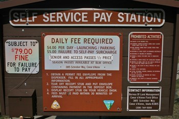
Bernard Landing on the Snake River
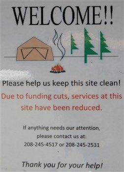
Bernard's Landing has been newly remodeled and now has a nice vault style outhouse, a boat launch, a dock and trailer...
Big Springs in Island Park
Big Springs a Natural National Landmark is one of the 40 largest natural springs in the world. 140 million gallons of...
Bruneau Arm Narrows Fishing Dock+
This is a video review of the fishing dock and facilities at Bruneau Arm Narrows on CJ Strike Reservoir in SW Idaho.
Camping on Eight Mile Road at Lake Meade
Free camping Nevada Eight Mile Road Lake Meade
Fern And Shadow Falls near Devil's Elbow Campground
Fern And Shadow Falls near Devil's Elbow Campground is a very beautiful area. Don't miss out!
Hiking to Oregon's Watson Falls
Watson Falls in western Oregon
Jump Creek Recreation Area

Marsing Pond Park and Sportsman Access Area
Marsing Pond provides fisherman's access to both the Snake River and the frequently stocked pond itself.
Mineral Ridge Public Boat Launch
Mineral Ridge Boat Launch is a public use facility on the east side of Lake Coeur d'Alene. At the time of our visit i...
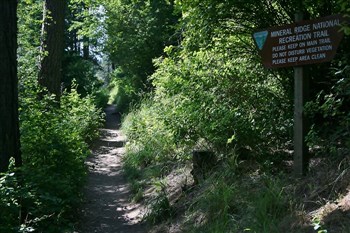
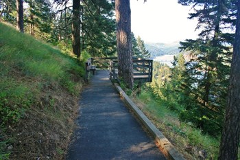
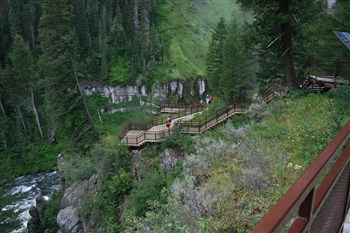
Mineral Ridge Scenic Area
Mineral Ridge Scenic Area on Highway 97 is located on the east side of Lake Coeur d'Alene near Beauty Bay. There is a...
Poverty Flats Long-term Camping
Free camping Overton Nevada Poverty Flats long term LTVA
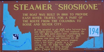
Shoshone Falls on the Snake River near Twin Falls
Shoshone Falls on the Snake River near Twin Falls has a 212 foot drop and a width of 900 feet. It is one of the large...
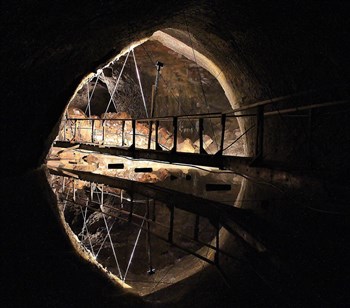
Shoshone Ice Cave near Shoshone, Idaho
Shoshone Ice Cave has a small museum and gift shop to browse while waiting for your tour of the cave. The cave is par...
Toketee Falls on the North Umpqua River.
Hiking to Toketee Falls in Oregon
Upper And Lower Mesa Falls on the Henry's Fork of the Snake River is an excellent place to visit. Upper Mesa Falls is approximately 114 feet high and 200 feet wide.
Upper And Lower Mesa Falls
Upper Landing Picnic Area above the St Joe River
Upper Landing Picnic Area offers a picnic area set above the St Joe River. It had clean and well supplies outhouses, ...
Walter's Ferry Sportsman's Access Area
Weiser Dunes OHV Play Area On Brownlee Reservoir
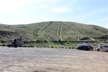
Weiser Dunes OHV Play Area is one of the few areas in Idaho that offers access to sand dunes. This view of the parkin...